
Three decades from now, the Bronte GO station could be surrounded by 20-storey buildings full of residents attracted by the option of a quick train trip into Toronto.
While the Oakville GO station has long been at the heart of a plan for high-density development, the town has now developed a similar vision for the Bronte GO station.
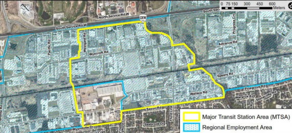
A proposal to designate the lands around the Bronte GO station as a Major Transit Station Area (MTSA) was presented during a May 10 meeting of the town’s planning and development council.
The 146-hectare area under consideration is bounded to the north by the QEW/403, 14 Mile Creek to the east, the established residential neighbourhood to the south, and Westgate Road and the Employment Area to the west.
The plan, which still needs approval from town council, would create a dense, pedestrian-oriented neighborhood with homes for 8,200 residents by 2051.
Buildings as tall as 24 storeys would be permitted immediately around the GO station, with medium-rise buildings allowed further from the station. The current plan calls for buildings to max out at 6-8 storeys closest to existing residential homes.
Like other identified growth areas in the town, the emphasis is on creating a pedestrian and transit-oriented community with jobs, shopping and recreation opportunities.
Employment districts will remain along the QEW corridor, Third Line and east of Fourth Line, with the area anticipated to be home to 18,600 jobs eventually.
Existing businesses may continue to operate, with redevelopment being entirely voluntary, said town planner Brad Sunderland.
Once the plan is approved, the town will no longer permit certain new businesses except in the zone's eastern area, noted Sutherland. These include:
- New drive-thru facilities
- Specific industrial uses
- Outdoor storage and processing companies
- New auto sales and service-related businesses
Other polices proposed for the area
Transportation
- Increase transit and active transportation use while expanding road network: bike lanes or multi-use trails along all major roads.
- Extend Westgate Road southward as a “key linkage” to improve north-south connectivity within the area.
- Move bus terminal to the south side of rail corridor per Metrolinx plans.
- Reduce parking supply and encourage targeted transit and shuttle services to and from the GO Station and key destinations.
- Create pedestrian linkages to the southern residential area to reduce walk time to the GO station.
Housing
- Inclusionary zoning to create a mix of unit sizes and housing types while ensuring a minimum number of affordable housing units are included in new developments.
Parkland
- 14 hectares of park and open space areas planned.
- Multi-use trail within utility corridor along northern edge of the rail corridor
- Use designated parkland money from the area to purchase green space.
- A possible path along 14 Mile Creek
Employment/Commercial
- Residential districts will encourage mixed-use, with bonus floors for office inclusion.
- Zoning will require commercial use on the ground floor of buildings facing main streets.
You can find more information on the proposal here.
Town planners are seeking feedback prior to developing a final recommendation for councillors to consider. That recommendation is expected by the end of 2021, with the planning changes requiring final approval from the region of Halton.