A storm the size of 1954’s Hurricane Hazel would result in Joshua’s Creek overtopping its banks and flooding as many as 163 downstream residential, commercial and industrial buildings, according to a town-led study.
But a storm of that size has less than one per cent annual chance of occurring, so infrastructure mitigations are too challenging and time-consuming to undertake, the study concludes.
Instead, it recommends creating an emergency preparedness plan that would identify properties facing flooding risks and provide owners with "a set of possible actions for flood protection."
Those actions could include installing temporary or permanent sandbags or aquadams, as well as sealing windows and doors and waterproofing utilities.
In the case of a flood warning from Conservation Halton, the town and property owners would implement their emergency preparedness plans.
A public comment period on the study and its preferred approach to flood mitigation runs until Nov. 5.
Evaluation of the impact of storms and climate change
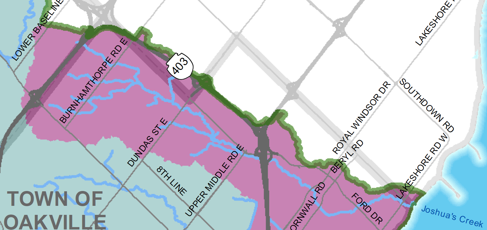
The study looks at the section of Joshua’s Creek from Upper Middle Road to Lake Ontario.
It concludes that in the case of a 100-year storm, which has a one per cent chance of happening any year, water from Joshua’s Creek would flood the parking lot at the Ford plant, overtop Royal Windsor Drive and spill into the Wedgewood Creek system.
Along with those impacts, a "regional storm event" like 1954’s Hurricane Hazel would result in spillage along Hwy. 403 plus overtopping the public pathway east of Constance Drive and the CN Rail tracks, leading to "inundation of the residential, commercial and industrial areas downstream."
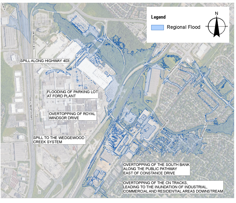
The greatest impact would be to private properties located downstream of the Metrolinx tracks in the right overbank area of the creek.
While the study considers the costs and benefits of adding flood control infrastructure or altering the Metrolinx rail bridge to reduce flood impacts from Joshua's Creek overflowing, it concludes they are "challenging," and there is a "low probability of damaging flood impacts."
"The modelled flood inundation boundaries, up to and including the 100-year climate change flood event, do not impose significant concerns to public safety, properties, or cultural and environmental features," says the study.
National report calls for increased transparency around flooding risk
A report released last month by the Canadian Institute for Climate Choices noted that flooding is currently the single largest cause of damage and loss to Canadian homes and buildings, with risks expected to increase dramatically due to climate change.
"As sea levels rise and rainfall increases, flood damage to homes and buildings could increase fivefold in the next few decades and by a factor of ten by the end of the century, with costs as high as $13.6 billion annually," noted the independent, non-partisan organization of experts, in its report.
It urged policy makers to update codes, regulations and funding decisions to determine what gets built and how it is maintained.
"Our findings suggest that to ensure new and existing infrastructure is ‘future-proofed,’ investment must dramatically shift toward making infrastructure more resilient," said the report.
The report also calls for increased transparency around flood risks, noting that about 500,000 homes and buildings across Canada are at risk of flooding, but there are few publicly available maps or resources to identify the risk.
South Oakville resident Erwin Banfi did not find out that his property was in a flood plain until he was denied a permit to build a new home on the land. He is a named plaintiff in a class action filed by local law firm Will Davidson LLP last October.
The suit seeks $1 billion in damages for south Oakville property owners whose land is now less usable, less valuable and at a higher risk of flooding due to what it describes as “an alarming rate of development” in northern areas of the town.
It argues that by replacing permeable green space with impervious roads, roofs and patios, development has added storm water and snow melt to creeks running southward through Oakville to Lake Ontario. The result, says the suit, is an expansion of the regulatory flood plain and an increased flooding risk for downstream residents.